Back مطار تويد نيو هافن الاقليمى ARZ Tweed-New Haven Airport CEB Flughafen Tweed-New Haven German Aeropuerto Regional Tweed-New Haven Spanish فرودگاه محلی توئید نیو هیون Persian Bandar Udara Tweed New Haven ID Tweed New Haven Regional Airport Polish Tweed New Haven Airport SIMPLE Фурудгоҳи маҳал туеҳид нейӯ ҳюн Tajik ٹویڈ نیو ہیون ہوائی اڈا Urdu
Tweed-New Haven Regional Airport | |||||||||||
|---|---|---|---|---|---|---|---|---|---|---|---|
 | |||||||||||
 | |||||||||||
| Summary | |||||||||||
| Airport type | Public | ||||||||||
| Owner | City of New Haven | ||||||||||
| Operator | Tweed-New Haven Regional Airport Authority | ||||||||||
| Serves | New Haven, Connecticut | ||||||||||
| Location | New Haven County | ||||||||||
| Opened | August 29, 1931 | ||||||||||
| Operating base for | Avelo Airlines | ||||||||||
| Elevation AMSL | 12 ft / 4 m | ||||||||||
| Coordinates | 41°15′50″N 072°53′12″W / 41.26389°N 72.88667°W | ||||||||||
| Website | flytweed | ||||||||||
| Maps | |||||||||||
 FAA airport diagram | |||||||||||
 | |||||||||||
| Runways | |||||||||||
| |||||||||||
| Statistics (12 months ending August 2022 except where noted) | |||||||||||
| |||||||||||
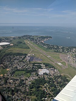
Tweed-New Haven Regional Airport[3] (IATA: HVN, ICAO: KHVN, FAA LID: HVN) is a public airport located three miles southeast of downtown New Haven, in New Haven County, Connecticut, United States.[4] The airport is partly located in the City of New Haven, which owns the airport,[4] and partly in the town of East Haven.
Tweed is one of two airports with regularly scheduled commercial service in Connecticut, the other being Bradley International Airport in Windsor Locks.
It is included in the Federal Aviation Administration (FAA) National Plan of Integrated Airport Systems for 2017–2021, in which it is categorized as a non-hub primary commercial service facility.
- ^ "Air Traffic Activity System". Federal Aviation Administration. February 9, 2016. Archived from the original on December 26, 2018. Retrieved February 9, 2016.
- ^ Cite error: The named reference
transtats.bts.govwas invoked but never defined (see the help page). - ^ "Tweed New Haven Airport". official website. Archived from the original on May 24, 2004. Retrieved May 21, 2004.
- ^ a b FAA Airport Form 5010 for HVN PDF. Federal Aviation Administration. Effective Sep 15, 2016.
© MMXXIII Rich X Search. We shall prevail. All rights reserved. Rich X Search